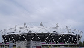
The Olympic Stadium
We proposed this walk to Ric and Gabriella who were over from Canada for a family party: it offered the prospect of seeing an unfamiliar part of east London and culminating with a view of the Olympic Park.
The walk, which we found on the London Town site starts at Limehouse DLR station. It actually pre-dates the games, but it is still easy to follow - and there are more signs now. You being by walking down to meet the Thames at Narrow St and we took the opportunity to have an enjoyable lunch at Gordon Ramsay's The Narrow pub. Here is the view west along the river, with the Shard as the main landmark.
You head east and immediately come to Limehouse Basin. Now a rather modern-looking marina, it was built in 1820 as the Regent Canal Basin, connecting the Regent's Canal to the Thames and allowing seagoing ships to offload cargo onto canal barges.
The Regent's canal heads north, but we followed a short stretch of canal leading to the Limehouse Cut to the east. The Limehouse Cut is apparently the oldest canal in London and dates from 1767. It connects the tidal River Lea to the Thames and by its use of locks avoided the need to wait for the tide. It originally entered the Thames to the east of here, and the link into Limehouse Basin was only made in 1968 - which must make it one of the last stretches of canal to be built.
The defining characteristic of the next two miles of tow path is that they are dead straight, which is very striking, but not visually very exciting, with flats and light industrial buildings on both sides. I suppose I should have taken a picture anyway.
At Bow Locks the canal and river converge, without meeting, as the canal runs beside the river. The path continues on a narrow spit of land in between the two. There has been a lock here since the 14th century, but the current version looks rather the worse for wear. If you look carefully in this photo, you can see a heron intently studying the algae-covered water of the lock. The towers of Canary Wharf lie behind.
A little further on, the Cut was home to this pair of Egyptian Geese, once an exotic collectors species, but seemingly increasingly common - rather like the green parakeets in London's parks.
At the end of this section we reached Three Mills. This area has been the site of mills since the Domesday Book. This is the Clock Mill, which was rebuilt in 1815-7 and is apparently the largest tidal mill in the world
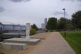
Behind the mills is the Three Mills Film Studio. We now entered Three Mills Island, which was "revitalised" as part of the Olympics. There is a pleasant walkway, permanent table tennis tables (to the right) and a new memorial to four men who died as a result of "bad air" while working in a well in 1901. Three of the men died trying the rescue the fourth.
There is a large grassy area to the right of the path and beyond it I could see an interesting cupola. After extensive research has discovered that it is the Abbey Mills Pumping Station. It was the of Sir Joseph Bazalgette, the architect of the London sewers, and its fantastic Byzantine styling, with polychrome brickwork led to it being nicknamed the Cathedral of Sewage. You can find out more from Wikipedia and see other pictures here.
We emerged onto the busy A12, now close to the Olympic Park and after some uncertainty - there are lots of temporary barriers blocking the paths - we found what seemed to be Pudding Mill Lane. There were further signs about the road being closed and more barriers, but after a snaking route between building sites we had confirmation that we were on the right track.
This brought us the the View Tube which overlooks the Olympic Park. From here there was a great view of the Stadium (see the photo at the head of this post) and of the Orbit, with Zaha Hadid's Aquatic Centre to the right.
There was lots of work going on in the Olympic Park, which will, it appears, re-open as the Queen Elizabeth Park next year. And some part of the other works and disruption is associated with Crossrail. We followed the Greenway away from the View Tube towards Hackney. There were more barriers everywhere, great piles of earth (spoil from tunneling perhaps) and a general air of abandonment which we found rather dismaying.
However, when we reached Hackney Wick overground station we saw real abandonment in the form of this derelict pub which had been given a curiously tasteful wash of pastel colours.
Conditions: cloudy, but mild.
Distance: about four miles.
Rating: three stars.


No comments:
Post a Comment