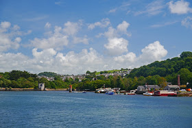
The Citadel from Mount Batten Point
Now for the final stretch of the Coast Path in Devon. We pick up the route at Mount Batten and pause to enjoy the view across the Sound to the Citadel, with the celebrated Plymouth Hoe on the left. We walk round past the marina and climb to then get a comprehensive view across the area known as Cattewater - the estuary of the River Plym. There is a just-so story to account for the odd name: there was allegedly once a rock formation which looked rather like a cat.
As we entered Turnchapel we saw the first of many variations on the usual methods of signing: finger posts and yellow arrows on low posts, both usually having the familiar acorn symbol. The idea with this older version was presumably that the appropriate directional arrow would be painted white.
Turnchapel has the character of a fishing village, with its neat cheerfully painted houses. Most have a doorcase, although in the case of the one on the extreme left it is painted on.
Passing behind some seemingly abandoned wharves, we followed a creek round to pass a new housing development on the end of Hooe Lake.
The lake itself has an interesting mixture of industrial buildings and hulks of old ships around its edges and at the far end what looks like a small castle. We followed a mixture of urban and woodland paths around the lake, passing another novel sign post on the way ...
... and emerged at Radford Castle, looking derelict and unloved. It sits on a dam separating the tidal Hooe Lake from the freshwater Radford Lake. All I can turn up on it is that it is "an early 19th century folly".
It has to be said that the next few miles were fairly grim: boat yards, light industrial areas, a length of the A379, chemical plants, more light industry. Not like anything previously seen on this scale in two hundred miles of coast! Of course Plymouth is by far the biggest urban settlement we have passed through and the most industrialised.
Eventually, we emerged onto a hedged tarmac path in Coxside which offers a great view back across the Sound to Mount Batten.
In the ivy hedgerow, alerted by a flash of orange, we spotted a Garden Tiger moth: staggeringly beautiful.
And at the end of the path, there is the ultimate signpost-cum-waymark. We saw other less dramatic variants too: red arrows on stone and red metal finger posts high up at right-angles on lampposts.
We pass the uninspiring National Aquarium building, cross the footbridge across the mouth of Sutton Harbour and reach the busy Barbican. It is too crowded and messy to be worth photographing. We continue along the harbourside to pass beneath the massive Citadel.
This picture shows one end. It was built in 1666 by Charles II and incorporated an earlier fort of Drake's time. Charles seems to have wanted to promote Plymouth as a cross-channel port and may also have had it in mind that the town supported Parliament in the still-recent Civil War - the guns were able to fire into the town as well as out across the Sound. It would have been nice to see the baroque Portal.
There was now a great opportunity to see Plymouth's newly refurbished art deco Tinside Lido, albeit looking into the sun. It originally opened in 1935 and was closed in 1992. It reopened after massive renovation in 2005.
Now we reached the famous Hoe. The first thing that struck us was the art deco column on the far side. It is in fact a war memorial to sailors who died at sea. After the First World War an Admiralty committee recommended that the three "manning" ports in Great Britain - Chatham, Plymouth and Portsmouth - should each have an identical memorial of unmistakable naval form, an obelisk, which would also serve as a leading mark for shipping. The memorials were designed by Sir Robert Lorimer, with sculpture by Henry Poole. The Plymouth Naval Memorial was unveiled by HRH Prince George on 29 July 1924. We saw the one in Portsmouth in February 2012 without realising that it was one of a trio.
Walking back towards the sea gives a fantastic view of Smeaton's Tower. This was once the third Eddystone Lighthouse, completed in 1759 and in use until 1877 when it was found to be unstable. The upper part was dismantled and relocated here as a memorial to its designer John Smeaton. The foundations and stub of the old tower remain on the Eddystone Rocks, close to the current lighthouse.
We walked through West Hoe to reach the monumental French chateau-style Duke of Cornwall hotel, which dates from 1863.
We somehow lost our way here and headed towards the Cremyll Ferry by a route that took us past the
imposing Royal Marine Barracks at Stonehouse. It dates from 1784, but the majority is mid 19th century.
At the the end of the walk, by the ferry, was the extraordinary entrance to the Royal William Victualling Yard. It dates from 1826-35 and was the work of Sir John Rennie. The 13 foot high figure on the top of the arch is the reigning monarch, William IV. The victualling work of the Yard is symbolised by the bulls' heads and tools on the facade.
Conditions: clear, sunny and warm.
Distance: 7.5 miles. We have now completed the coast of South Devon. Next stop Cornwall!
Map: Explorer 108 (Lower Tamar Valley and Plymouth).
Rating: Four stars for the best bits, but a lot was very dreary.


No comments:
Post a Comment