To the Edge
I visited this area a lot in the 1990s, and often saw the splendid sign "To the Edge", but I never actually went. A visit to friends provided a chance to rectify the situation. I knew of course that the edge in question was really an escarpment of soft sandstone overlooking the Cheshire Plain.
This walk begins in fact at another of the parking places on the Macclesfield to Alderley Edge road, by Beacon Lodge. You cross the road and head south east in a meandering route that takes in woodland, Artists Lane (presumably there is a story behind the name), Bradford Lane and some nice undulating open country.
Having almost circled back to the start, you then head off east along a track in the direction of Alderley Edge. The great disc of the Jodrel Bank observatory is soon dramatically visible on the horizon.
A bit further on the track becomes a drive then a road and you enter one of the smart residential areas of Alderley Edge, passing by houses which range from substantial in size to vast. You follow a path to the right back down to the main road, which you cross to walk along more residential streets.
Soon, you climb up Squirrel's Jump (!) and at the top continue climbing to enter the National Trust property of Alderley Edge. Here at last, you look down on the Cheshire Plain.
Now things start to get more interesting. You walk along the side of the escarpment for a way with pleasant views through the beech trees. After a while you have to turn right up a steep-looking set of steps.
Having struggled to the top you now walk along just underneath the escarpment, passing a series of rocky outcrops. The first is the Wizard's Well, which apparently looms large in Alan Garner's book Weirdstone of Brisingamen. Carved in the rock above the well is the face of a wizard and the inscription "Drink of this and take thy fill for the water falls by the Wizhard's Will". The carving was added around 200 years ago by Robert Garner, Alan Garner's great-great grandfather. The book passed me by - I guess I am the wrong age - so I did not give the Well the attention others would think it deserved.
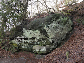
One of the other outcrops shows the red sandstone very clearly.
After the outcrops end, you climb through woodland to reach Stormy Point, a red sandstone plateau, with fine views over the Cheshire Plain and the Peak District beyond. I had finally reached the edge!
From: Macclesfield Outdoors, an initiative of the local council.
Map: Explorer 268 (Wilmslow, Macclesfield and Congleton).
Distance: a bit over four miles.
Conditions: cloudy at first, but later mild and sunny. Muddy underfoot.
Rating: four stars, but only for the National Trust section. It was good to approach it from below.


No comments:
Post a Comment