Pages

Sunday, 18 October 2020

Golden Cap


                                                            Golden Cap

Golden Cap is famously the highest point on the south coast at 627ft / 191m above sea level. The name derives from the distinctive outcropping of golden greensand rock at the top of the cliff. We crossed Golden Cap on a 6.5 mile South West Coast Path walk from Eype to Charmouth in 2012. It seemed about time to see it again. We started this time from Seatown, accessed via a narrow road down from Chideock.

We parked at the busy car park, owned by the Anchor Inn nearby, and headed back up the narrow lane to soon turn left following a sign to the Coast Path and Golden Gap. This led first through woodland and then to more open land. We soon realised one feature of this walk: it was very popular.

Looking back, we could see Thorncombe Beacon, with the Isle of Portland in the distance.


Golden Cap became more striking as we got closer (see photo at the head of this post). And naturally the higher we got, the more extensive was the sweep of coastline that could be seen behind us.

We passed the simple memorial to the Earl of Antrim, who, as Chairman in the 1960s and 70s, spearheaded the National Trust's drive to buy up sections of the coastline before developers moved in. 

There were great views to the west ..


We were very struck by the patchwork quilt of small green fields inland - astonishingly different from the vast arable fields of Wiltshire where we have also walked a lot lately.

Our route now took us downhill to reach the ruins of St Gabriel's church a few hundred yards inland. It apparently dates back to 1240. 

This is all that remains of the lost village of Stanton St Gabriel. I have read that the main road was moved a mile and a half inland at some point, because of coastal erosion, and that this was the cause of the village's demise.

We now headed inland along a narrow lane to reach a crossroads. We turned right and continued up Muddyford Lane, which after a while became extremely steep. We turned right onto a concrete track and passed a National Trust farm with the great bulk of Langdon Hill (178m) on our left. After a couple of fields and large grassy area we found Pettycrate Lane (a muddy track) which headed all the way downhill to meet the Chideock to Seatown road, running more or less parallel with the route we came up on. It was very quiet, although we still crossed a few walkers coming up the hill. Turning right at the bottom we soon returned to the car park.

Conditions: cool and cloudy.

Distance: 4 miles.

From: 50 walks in Dorset (AA).

Map:  Explorer 116 (Lyme Regis & Bridport).

Rating: four stars.

Saturday, 17 October 2020

Osmington MIlls and Ringstead Bay


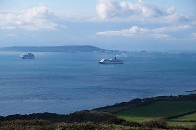
                                                                            Parked cruise ships in Ringstead Bay

We are down in Poole for the weekend and  we thought it was time to renew our acquaintance with the South West Coast Path. This circular walk starting from the car park high above Ringstead Bay seemed to be just the ticket. The car park offered wonderful views over the bay, where no less than eight cruise ships are currently parked. Portland can be seen behind.

Soon after we started we saw four small waves in front of the liner in the centre of the picture, three in line abreast and a fourth one a few metres behind. We are pretty sure they must have been dolphins, although we were too far away to see any confirmatory evidence.

We followed the high path for a while and then turned right to descend and join the Coast Path at Ringstead Village. Soon we passed the wooden chapel of St Catherine's-by-the-Sea. It was built in 1926 by the widow of Dr Linklater, a Prebendary (Canon) of St Paul's Cathedral. The Linklaters had lived in nearby Holworth House.


Soon we passed an amusing signpost which I remembered from when we first passed this way in November 2011. The signpost was more vertical then.


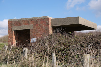
We continued woodland and once the coast was clear passed a war time gun-emplacement - we have seen quite a few gun emplacements and pill-boxes in recent walks.

 Looking back, we had a fine view of the imposing headland of White Nothe. The building you can see was once Coastguard Cottages, now holidays lets. In the distance, is (I think) St Alban's Head.


We continued along the grassy cliff and passed the wreck of a ship near the shore. There was a lovely view of Weymouth Bay beyond it.

We climbed and then gradually descended towards Osmington Mills, turning right just before the village to climb uphill through a caravan site and then continue on a steepish climb. A level track brought us to the road from Upton which we had followed to get to the car park. Unavoidably, we had to walk about a mile along the narrow lane dodging the passing cars. It wasn't much fun, but we did enjoy the long closed valley which ran along beside the road on the left.

Conditions: bright and sunny.

Distance: 5 miles.

From: Jurassic Coastal Walks by Nigel J Clarke.

Map:  Explorer OL15 (Purbeck & South Dorset).

Rating: four stars.

Wednesday, 14 October 2020

Sugar Hill and Liddington

                                                                                                        Sugar Hill

We followed up Saturday's walk from Aldbourne by going further along the B4192 to park in a lay-by and walk towards Sugar Hill. The last part involved a steady climb. Below is the view looking back from just below the top. In the distance is the ridge we will walk back on and then turn left to walk down the hill back to the car.


On reaching Sugar Hill we turned left and followed a path which gradually got nearer to the road (the line of trees in the photo). We enormously enjoyed the wide open country.


We reached and soon afterwards crossed the road and climbed up to be confronted by this World War II gun emplacement. It was a bit different from the pillboxes you see all along the Kennet and Avon Canal.
 

There was a nice view looking back towards Sugar Hill, but unfortunately the cloud had begun to thicken.


We carried on along the track to soon see Liddington Castle off to the right. It dates from the Bronze and Iron Ages and was one of the earliest hill forts in Britain, with first occupation dating to the 7th century BC. Perhaps wrongly, we decided not to pay it a visit, feeling that we have seen quite a lot of hill forts on our walks.


A bit further on we turned left on a track with a Ridgeway sign and headed south, with again nice views across to Sugar Hill.


A little further on we turned left and headed downhill towards where we had parked.

Conditions: cool but pleasant.

Distance: 5 miles.

From: 100 walks in Wiltshire.

Maps:  Explorer 157 (Marlborough & Savernake Forest), with slight incursion into Explorer 170 (Abingdon, Wantage & Vale of White Horse).

Rating: four stars.

Saturday, 10 October 2020

Aldbourne, Marridge Hill and Preston


                                                                                                        The Square, Aldbourne

We started this lovely walk from The Square in Aldbourne and made a short detour to take a picture of the church of St Michael. It is of Norman origin, but was partially rebuilt in the 14th century and partly restored by William Butterfield in the 1860s. Pevsner's review suggest that there would be plenty to see inside the church, if it were open.


To the right of the large green some filming was taking place involving a yellow car and two actors. The car's number plate was WHO 1, which might be significant, but it appears that the filming was for a documentary.


We walked up the hill along the road towards Baydon. A house on the left sported a fine flagpole and a colourful flag: red and black with a yellow circle. It turns out to be the flag of the Australian aboriginal people. But what is it doing in Aldbourne?

 Further up the hill we turned right along a track which brought us to some gallops.


Now we had a steep climb at the top of which there was a lovely view back towards the village.


We followed a field-edge path for some distance and then climbed a track up Pigs Hill, with nice views off to the right.

At the top of the hill we turned right along a track and were delighted to spot a lovely Red Admiral in the hedgerow.

The track became a road, passing the scattered houses of Marridge Hill. We passed Baydon Manor, which might have been interesting but we couldn't see much of it. We soon turned right to descend along a minor road to reach Preston. It is only a hamlet, but it does sport a pretty former Toll House.

We now climbed steadily to reach the top of Green Hill. On the way there was a lot of this dramatic Black Briony in the hedgerows.


We then turned left along a track to reach the edge of Aldbourne where we continued along a narrow pavement into the village. We enjoyed the old Malthouse on the right.

Conditions: cool but pleasant.

Distance: 5 miles.

From: 100 walks in Wiltshire.

Map:  Explorer 157 (Marlborough & Savernake Forest).

Rating: four stars.