Pages

Sunday, 22 November 2015

Rochester

Rochester Castle

I have been meaning to visit Rochester since I read the sad tale of its loss of city status. It had been a  city since 1211, but ceased to officially be one because of an administrative oversight. The former Rochester-upon-Medway City Council neglected to appoint ceremonial Charter Trustees when Medway became a unitary authority in 1998. Unfamiliar with the archaic rules governing city status, they did not realize that Charter Trustees would be needed to protect the city's status. Consequently Rochester was removed from the Lord Chancellor's official list of UK cities. There does not seem to be a route back.

I started my walk at the railway station and turned right into quiet upper part of the High St. Crossing Station Hill, you enter the more characterful and livelier part and soon pass a section of town wall on the right and a handsome half-timbered house on the left.


A little further along on the right is La Providence. This was originally founded in the City of London in 1718 as a hospital for Huguenot refugees and later relocated to Hackney. It was further relocated in 1959 when this pleasant square of early Victorian houses was acquired and refitted as sheltered accommodation for elderly people of Huguenot descent. It is perhaps slightly surprising that such people can still be readily identified.


Next is a more conventional almshouse, Watts's Charity, the Poor Travellers House, endowed by the will of Richard Watts in 1579 to provide a night's lodging for six poor travellers. It apparently continued in this role until the Second World War.


Then the narrow street suddenly opens out on the left hand side to offer a great view of the Norman cathedral, begun in 1080 on the site of a Saxon cathedral dating from 604. It claims to be the second oldest in the country (I think Durham is the oldest).


Continuing along the High S, you come to the old Corn Exchange, with its large clock. Unfortunately, it is currently concealed behind scaffolding.


Continuing along the High St towards the river Medway, you come to the imposing Guildhall of 1687 - it too was hidden behind scaffolding. Turning left at the, you approach the keep of the Norman castle. This is the tallest one in the country (113 feet high) and was started in 1127.


Circling round the perimeter of the keep (you can visit, but I did not have time today), you come out in front of the cathedral, with its magnificent facade and dramatic silhouette.


Inside, the nave has classic Norman round arches with geometrical patterns above them.


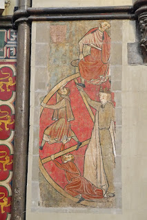
In the choir there is a lovely fragment of a medieval wall painting.


As you emerge from the west door, there is a great view across to the Castle, indicating how large the surrounding walls were (this is the photo at the head of this post. Turning left and left again into St Margaret's St, there is a view of the 15th century Prior's gate, the most compelte of the three gates to the cathedral close.


I walked along St Margaret's St in search of some of Rochester's lesser-known sights, its fine almshouses. On the right, is this imposing building of 1724, once a workhouse (a relatively early example) and school, and now part of King's School.


At the top of the hill, a delightful terrace of three houses had beautiful art nouveau floral decorations above the windows.


Further on I came upon this splendid fortification, Fort Clarence. It was built between 1808 and 1812 to defend Rochester from land attack or river landing and originally stretched from Maidstone Rd to the River Medway. Some parts of the structure were demolished in the 1930s and again in the 1960s. It is now apartments.


Now along Borstal Road and left into Priestfields to reach Foord's Almshouses of 1927, by the architect E Guy Dawber. This is an impressive, large group in a very traditional style for the date.


At the end of Priestfields, I turned left into Maidstone Rd, now heading back towards the town centre, and found Watts' Almshouses of 1858 on the left. This is a long and ornate terrace, set back from the road, with an extrordinary building in the centre. The invaluable Images of England website descibes it as "a good example of vigorous, studiedly detailed, mid-Victorian C17 domestic revival architecture".


It remained only to plod back to the station.

Conditions: a really nice, bright day.

Distance: about 6 miles.

Rating: five stars.

Thursday, 19 November 2015

Northampton

The Guildhall

Northampton is the second largest town in England (after Reading) and seemed a worthy target for an outing on the first dryish day for a while. I followed the Northampton Heritage Trail available on the Borough Council's website.

The walk starts at the Church of the Holy Sepulchre (1103), the oldest church in the town and one of only four surviving round churches in the country. The tower was added in the 15th century and the church was further enlarged in the 1860s.


These churches were built by returning Crusaders on the model of the Holy Sepulchre church in Jerusalem. The others are: Temple in London, the Round Church (correctly also Church of the Holy Sepulchre) in Cambridge and St John the Baptist, Little Maplestead, Essex. Having now seen three, I can feel a trip to Essex coming on.

Now you walk down to the very large Market Place, where the market was in full swing. My eye was drawn to this house in a quiet corner. It is the Welsh House, which dates from 1595 and survived the great fire of 1675. The facade was recreated in 1975 when the adjoining Grosvenor Centre was built.


At the bottom the Market Square I turned into pedestrianised Abington St which had a wide variety of building types including this rather wonderful art deco one.


And at the top of the road this even more splendid former cinema (it opened as the Savoy in 1936).


A right turn led to St Giles Church and across the churchyard in St Giles St were very grand early victorian houses. None of these last three were mentioned in the heritage trail leafle.


I followed Cheyne Walk and glanced at Becket's Well in Bedford Road before crossing the road into Derngate to encounter the greatest surprise and delight of the whole walk: number 78 is a house remodelled in 1916 by the great Charles Rennie Mackintosh, apparently his only work in England. The client was W.J Bassett-Lowke. And even more wonderfully, it is open to visit. The front is undistinguished, but the rear elevation shows evidence of Mackintosh's work.


You enter the house via the remarkably unspoiled kitchen and climb the narrow stairs to the fabulous living room at street level. There is wonderful stencilling on the front wall ...


... and equally marvellous coloured glass on the opposite wall, with the staircase behind.


At the end of Derngate is the extravagant Guildhall (see photo at the head of this post) by E W Godwin., completed in 1864. Next door is the 1992 extension. According to Wikipedia, it "was made to be sympathetic to the style of the rest of the building and the final choice made by public ballot from a list of several alternatives". I think it tones in very well.


Further on, you pass the Theatre, Museum and Session House to reach the imposing All Saints church. It was built after the great fire of 1675 to replace All Hallows church which was destroyed in the fire. The portico was added in 1701.


Now along Bridge St to reach the former St John's hospital and church, now a restaurant.


I now embarked on the optional excursion, involving an alleged 20 minutes walk to the south to see Delapre Abbey and Queen Eleanor's Cross. You cross the river Nene (not very pretty) and pass the Carlsberg brewery to then reach the entrance to Delapre Park. The Abbey lies at the end of long drive and is one of those quite numerous country houses built on the site of a dissolved abbey - Lacock Abbey or Mottisfont Abbey would be other examples. Unfortunately, it is being comprehensively restored and although I prowled all the way around the perimeter this was the best I could do:


Back to the road and up a steepish hill brought me to Queen Eleanor's Cross in Hardingstone. This is one of the 12 crosses erected by Edward I when his wife Queen Eleanor of Castile died in 1290. Eleanor died near Lincoln and the crosses marked the overnight stops of her funeral procession on its way to London. (I was interested to learn while researching this that the best-known cross, Charing Cross, just outside the station, is a Victorian replica. The original stood in Whitehall, not far away, and was destroyed during the Civil War.)


The long trudge back took more like half an hour, but it was good exercise and great to have seen one of only three of the original crosses still standing. And, according to a helpful plaque, this one had fallen down by 1713 and was then restored.

Back in the centre, I walked along Gold St into Marefare passing Hazlerigg House, an impressive Elizabethan building of 1580.


At the end was one last gem: the beautiful St Peter's church of 1160. Unfortunately, the churchyard and the church itself were both closed so I could not explore further. This may because the church is now redundant.


Conditions: grey and showery at first, becoming brighter later.

Distance: 5 miles including the diversion, more like 2 otherwise.

Rating: four stars. Very interesting and varied,