Pages

Wednesday, 30 September 2015

Widemouth Bay to Bude (South West Coast Path 83)

Widemouth Bay

Only a short stretch of Coast Path today as I have hurt my ankle again. We continue along the back of the beach to reach the headland of Lower Longbeak. This is the view north with Higher Longbeak in the foreground and the white satellite dishes of Bude GCHQ in the background.


We walk along the cliff top to reach Higher Longbeak and quite a dramatically rocky shoreline. The tip of a pinnacle of rock has just caught the sun in the foreground.


Phillip's Point, at the end, has attractive folds of sandstone, unusual in Norther Cornwall.


Looking back, the stone pinnacle can be seen with a sort of stone doughnut behind it.


After the hamlet of Upton, the road which has been nearby heads off to the east and the path crosses an unexpected wide grassy area behind Efford Beacon and along to Compass Point on the edge of Bude. This is marked by Storm Tower built in sandstone in 1835. It is based on the Temple of the Winds in Athens and has the points of the compass marked on each of its eight faces.


Just beyond this you turn inland and walk above the sprawling beach and small harbour.


The beach huts on the opposite side provide a nice splash of colour.


Then you pass the massive sea lock which marks the end of the Bude Canal. This rather surprising structure was built in 1823 and runs only a few miles inland to merge with the river Neet. Its main purpose was the transportation of sea sand inland for use as a fertiliser. The sand was collected from the beach and conveyed by a narrow gauge railway to the jetty on the right of this picture.


We diverted slightly at this point to see Bude Castle, built in 1830 by the polymath and inventor Sir Goldsworthy Gurney.


In front of the castle is the rather lovely Bude Light, a millenium homage to Gurney by Carole Vincent and Anthiny Fanshawe. "The cone incorporates fibre optic star patterns which sparkle at night" (Pevsner). The colour-scheme is very pleasing.


Conditions: warm and sunny.

Distance: 3.4 miles (distance now covered 506.2 miles).

Grading: Easy.

Map: Explorer 111 (Bude, Boscastle & Tintagel)

Rating: Four stars, surprisingly interesting and emjoyable.

Tuesday, 29 September 2015

Crackington Haven to Widemouth Bay (South West Coast Path 82)

The towering headland of Pencannnow Point

We pick up the coast path at Crackington Haven and start by climbing up to Pencannow Point, which we pass to the back of. The tide is out today and there is a nice view back towards Cambeak.


Next up is a steep descent into a long valley and then a corresponding climb up the other side.


Once at the top, an inviting ridge stretches out ahead.


Across the valley the spire of St Genny's church is visible. The ridge continues and at the end then is a lovely view back down the valley. 


There now follows a section of high grassy cliff (Lower Tresmorn) which ends with a vertignious descent down to just above a seemingly unnamed inlet.


The inland valley is (or was) known locally as Butterfly Valley and once was home to a colony of the rare Large Blue butterflies which became extinct in the late 1970s. We have been seeing a reasonable selection of butterflies as we walk along: Large and Small Whites, Red Admiral, Small Tortoiseshell, Speckled Wood, but now to great excitement we spot our first Clouded Yellow of the year.

The opposite side is Chipman Cliff, a steep and slippery climb.


The next section along the cliff top is reasonably level and views of our destination, Widemouth (pronounced Widmuth) Bay soon become available.


This area is called The Dizzard and is notable for the tree-lined slopes leading dpwn to teh sea. Theer are Sessile Oaks, Mountain Ash, wild Service Tree, Beech, Hawthorn and Blackthorn. It is said to be a remnant of the prehistoric forest which once covered the whole country.  Briefly the path dips down into the woods near Bynorth Cliff and then continues until above Milloook.


 Here it joins the road which passes behind the strange rocky cove with its gravelly beach - apparently a sort of geological heaven with extraordinary rock formations. It leads to another steep climb (we have a leaflet produced by the North Cornwall Heritage Coast and Countryside Service which describes it as one of the steepest on the coast path and we are not inclined to disagree). A further clifftop section rejoins the road above Wanson Mouth where the coast continues to have a sort of black rocky reef. It is probably rather a crass comment, but we found this whole stretch of coast rather gloomy and oppressive - where were the nice sandy beaches we had seen previously in North Cornwall?

On this section of road our day was brightened hugely by the sight of a newly emerged Painted Lady which offered a lovely image with the sun behind its wings.

 At the bottom of the hill we took a path on the left to reach and then walk behind Widemouth Bay.


The North Cornwall Heritage Coast and Countryside Service leaflet mentioned earlier describes this as "one of the finest sandy beaches in North Cornwall". To be honest, having seen several sandy beaches in North Cornwall, I have to say that they must be joking. I would go for "dismal".

Conditions: warm and eventually sunny, but hazier than yesterday.

Distance: 6.8 miles (Distance now covered 502.8 miles - woo hoo!)

Grading: Strenuous.

Map: Explorer 111 (Bude, Boscastle & Tintagel)

Rating: Four stars, principally for the first section.

Monday, 28 September 2015

Boscastle to Crackington Haven (South West Coast Path 81)


Boscastle

We are back on the South West Coast Path after a summer break - Cornwall is just too crowded in the summer - and we pick up our route at Boscastle. We walk up right hand side of the stream which flows into the harbour and past the tea shop with its pretty gothic windows to look down over the harbour where the tide is out.


We climb the steep cliff behind Penally Point and head along at cliff top level with the coast stretching away ahead to the oddly named headland of Cambeak.


We are already starting to see lots of Small Tortoiseshell and Red Admiral butterflies and this would continue for the rest of the walk. We make the first of several steep descents from Hillsborough to reach a cove called Pentargon, where there is apparently a waterfall when conditions are right. Not today though. There is a nice view out to sea however.


Now we climb Beeny Cliff and continue on a mid-cliff path with the rocks called the Beeny Sisters out to sea, a known spot to see seals. Two women walkers we passed had paused to do just that, although we couldn't see any ourselves.


Now we were on a high cliff path with next section to Cambeak stretching out before us and looking rather bleak it must be said. We didn't realise until we had climbed up to it, but the rocky bluff on the right is High Cliff, unimaginatively named but at 223m just beats Golden Cap in height and is apparently the highest sea cliff in Cornwall. (The only higher one in England is Great Hangman near Combe Martin in North Devon, which is 318m.)


At Rusey Cliff there was clearly going to be a substantial descent and then climb and in fact the path went further down towards the sea than I had realised when taking this picture.


 The long steep ascent on the other side brought us to High Cliff, and a grassy area just beyond. The view was green and inviting, allowing us to dream that the hard climbing is all over.


Soon you begin another descent and the distinctive rock formations of this section of coast become clearer: Samphire Rock (one of the few such rocks not called Gull Rock), Northern Door (a natural sea arch, although it appears on closer inspection to have been bolstered with some stone blocks) and Cambeak.


On the descent we spotted to the left a number of goats with long curved horns.


As you get closer, Cambeak looks for all the world like stone monster: head, eye, mouth, neck, body.


Time for another descent and then a steep climb, eschewing the obvious shortcut to the right, to climb Cambeak and enjoy a fine view toward our destination, Crackington Haven.


 Just another steep 50-step climb bars the way and soon we are descending the cliff towards the village. It looks nothing much, but apparently the high water conceals a sandy beach and at low water it is a popular destination.


Conditions; remarkably warm and sunny.

Distance: 6.8 miles (distance now covered 496 miles).

Grading: Strenuous.

Map: Explorer 111 (Bude, Boscastle & Tintagel)

Rating: Four stars.

Sunday, 27 September 2015

Butterfly picture cards from 1963

The cover of the book

I was recently given, by my friend Del, a set of Brooke Bond picture cards of British Butterflies dating from 1963. It was a lovely idea and I wondered why I hadn't collected them at the time - I think I was more interested in trains. I found it fascinating to compare the text with the situation today.

The introduction begins: "The butterflies of the British Isles are slowly decreasing in number and variety, mainly owing to the widespread and often pointless use of chemical sprays ..." So you might think that not much has changed in the last fifty years. However, the next page and half are devoted to butterfly collecting and describe the use of nets, killing bottles and setting boards and pins! So that is one area where attitudes have changed dramatically in the last 50 years.

One slight surprise was the inclusion of  the Large Tortoiseshell, described as "once fairly common", but "now found but rarely". The current assessment would be that it is extinct as a breeding species, although one or two vagrants are spotted each year.

The Large Blue is described as being "found only in the South West of England, mainly in Devon and Cornwall". It had become extinct by 1979 as a result of agricultural changes: according to Jeremy Thomas (The butterflies of Britain and Ireland) many sites were simply ploughed and seeded, while others were abandoned and became unsuitable once the rabbit population was dramatically reduced by mixomatosis in the 1950s. It was of course reintroduced in the 1980s and now can be found at a number of sites in Somerset and the West Country.

On the other hand, the Comma is described as "a rare butterfly found locally in the south of England". It is now common and extending its range northwards. Interestingly, experts do not really know what has accounted for the Comma's expansion in numbers and territory, although climate change is thought to be playing a part now.


Finally, the Red Admiral is described as "one of our most common and most beautiful butterflies" and this is certainly a judgement which remains unchanged, even if the Peacock has been voted the most popular in recent years.


Del also gave me sets of butterfly cards for North America and the World. I don't know enough to offer a commentary on these, but they were very timely as I find myself becoming ever more fascinated by butterflies and keen to see as many species as possible (my life list currently stands at a very modest 145).

Friday, 18 September 2015

Malmesbury

The Market Cross

It has been a while since we did any walking in England, so it was great to have a couple of hours free to visit Malmesbury when we were in the area. We followed "A walker's guide to Malmesbury", 50p from the Tourist Office in Cross Hayes. From there we quickly reached the Market Cross
of about 1500. It is "one of the finest in England" according to Pevsner.

The adjacent Tolsley Gate leads to the celebrated abbey. The gate was once the town gaol and the two doors lead to windowless cells where drunks were thrown to sober. The walk leaflet suggests this as the origin of the expression "blind drunk". Pevsner dates it to about 1800.


Going through the gate, you come to the abbey church. It dates from the 12th century, but was much reduced in size at the Dissolution of the Monasteries. What you see now is part of the nave: the transepts, crossing tower and chancel are missing.


The great south porch is extremely impressive and is "among the best pieces of Norman sculpture and decoration in England" (Pevsner). The interior is monumental and imposing with an early use of pointed arches, massive columns and delicate moldings and sculpture. There is a curious box-like structure on the right hand side which nobody seems to know the purpose of.


To the left of the abbey is the Old Bell hotel, once the abbey's lodging house for guests. A group of lads were enjoying a drink, perhaps getting ready for the Rugby World Cup.


Now along Abbey Row, where we enjoyed this unusual house with its canopied first floor window,  tucked between two much larger ones.


At the end St Mary's St led to the pretty triangular area called Horsefair, once the site of an unofficial market.


We walked then along West St and Bristol St to suddenly feel that we had left the town and arrived in the country. Turning into Foxley Rd we crossed a stile and followed a grassy path along the water meadows by the River Avon. At Daniel's Well there was a nice view back towards the abbey on the left and the spire which is all that remains of St Paul's church.


Our route now took us back into the town and past the Market Cross to reach Oxford St, at the end of which is the well-named Tower House. the house itself dates back to the 16th century, while the tower was built in the 19th for star gazing. I had read that Oxford St also contained Jenner's Almshouses  (built 1729, rebuilt 1825) [almshouses are a special interest of mine]. They proved to be much altered and in such a cramped site that they were impossible to photograph.


From here Cross Hayes and Silver St brought us to St John's St, where the St John's almshouses of 1694 incorporate the reset arch of the medieval Hospital of St John.


It remained only to walk up the High St and take a right back to the car park. This is the start of the High St, the first house of which has unusual curved walls and is known as the Round House.


Conditions: a lovely sunny afternoon.

Distance: about 2 miles.

Rating: four stars. A delightful town.

Thursday, 17 September 2015

The Cinque Terre: Overview


 Vernazza
Introduction

Recent posts have described our wonderful walks in the Cinque Terre: Monterosso to Vernazza, Vernazza to Corniglia, Manarola to Riomaggiore, and also Levanto and Genoa. In this post I will try to summarise what we learned. Our experience was that it was hard to find detailed information before we arrived and several things remained mysterious the first day or two we were there. Hopefully this will be helpful to other would-be visitors. (Disclaimer: these are my personal observations, which I believe to be accurate, but I cannot accept responsibility for anybody relying on information which proves to be erroneous.)

About the Cinque Terre

The Cinque Terre are five pretty villages (in order from north to south: Monterosso, Vernazza, Corniglia, Manarola, Riomaggiore) located along a stretch of the coast of Liguria in Northern Italy linked by an 11km walking trail, the Sentiero Azzurro (Blue Trail). The section between Corniglia and Riomaggiore is known as the Via Amore (Street of love) and is said to be wheelchair-friendly; the rest of the trail is rocky and involves steep ascents and descents. A unique feature is that the villages are linked by rail: trains on the Sestre Levante to La Spezia line stop at each one.

Is the path open?

We knew that the path was closed in 2011 after torrential rain caused mudslides, but we found it hard to establish what its current status was. The Latest News page of the Cinque Terre portal, which you would expect to be a definitive source, has no information more recent than 2002 (!), while Wikipedia's page refers only to it being partly closed in 2012. There probably are more up to date websites. When we arrived we found a map in the Cinque Terre Office at Levanto railway station which had a handwritten amendment showing that the path was in fact still partly closed: the Corniglia-Manarola-Riomaggiore stretch has not yet (as of September 2015) reopened.

I am not going to speculate why this information is so hard to come by, but it is also worth noting that the signposts, which are generally very good, have not been altered either. As you arrive in Corneglia, for example, there are still signs pointing the way to Manarola and causing confusion and frustration.

Corniglia

Does it matter?

Not really. It is frustrating for completists like me, but it really does not detract from what remains a great experience. Corniglia-Manarola-Riomaggiore is the least interesting section to walk, the villages themselves are still accessible by train, there is a straightforward inland alternative from Manarola to Riomaggiore (just over 1h) and a more demanding one from Corniglia to Manarola (2.5h).

Access

As well as the coastal path, there is a network of paths in the mountainous area inland from the coast (the mountains reach 700 km above sea level). Access to the inland paths is not controlled, but to walk the coast path you have to purchase a one- or two-day Cinque Terre Card (from the Cinque Terre Point at railways stations). These come in two forms: walking only and walking plus train, the latter allows unlimited travel on the trains. There are checkpoints at or near the start of each section of coast path and you can pay here as well.

Manarola

Trains and maps

The train links provide great flexibility in planning your walks. Most people know that you have to validate your ticket before travel (i.e. have it stamped at a green machine located at various points on the station). The same also applies to the Cinque Terre Card, although it only has to be done once.

When you buy a Cinque Terre Card you are also routinely given a timetable and a very good map (we foolishly bought one which was inferior in a bookshop).

One thing which foxed many people us included was the two screen information displays showing arrivals and departures. It only made sense once we clocked that each train service in Italy has a unique number and by comparing these you can see exactly what is going on.

Temporary path closures

One day we were there the coastal path was closed because of the threat of thunderstorms. We were trying to buy tickets for the next day at the Cinque Terre Point when we found out. I am not sure if there is a system for publicising these closures, but we did find that the excellent Accuweather weather forecast site had information on weather warnings, so this would at least alert you to the need to check.

Where to stay

We stayed in the pleasant town of Levanto, one stop to the north of Monterosso, and travelled in by train each day. This worked very well although lots of other people had the same idea and on the sunniest day there was a long queue for tickets (we bought a train ticket from the machine and a walking card at our destination, which saved some time).

 Levanto station: the train was late

We liked Levanto, which has a nice beach and some good restaurants, but I can't make a comparative judgement over the other villages.

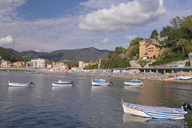
Levanto

North-South or South-North?

I suppose because we were staying to the north of the Cinque Terre, we decided to walk North-South, but clearly plenty of people were coming the other way. One key factor to bear in mind is that at Corniglia there is a massive ascent (said to be 358 steps) from the train station to the village. It certainly makes better sense to finish a walk there than to start one!

Steps down at Corniglia