Pages

Wednesday, 16 July 2014

Edgeworth

A Marbled White, today's signature butterfly

A walk in a remarkably rural part of Gloucestershire with my friend Mervyn. We set out from Jackbarrow Farm, a mile or so west of Duntisbourne Abbots and headed across fields to enter the aptly named Thick Wood. We descended the side of a valley through the wood and reached the bottom, crossing the tiny river Frome, climbing up across more fields to reach the hamlet of Edgeworth at the pretty churchyard of St Mary's church.


The church is of Saxon origin, with Norman and later elements culminating in the almost obligatory Victorian restoration. Next to the church stands the impressive Manor.


It was built about 1700, but the lovely main facade with its Tudor windows and renaissance entrance dates only from 1899.

We headed east past some houses and then across what might have once been - or maybe still is - the park of the Manor House.


This eventually brought us to a quiet, isolated north-south valley, with the Holy Brook running at the bottom. A number of Marbled White butterflies were immediately in evidence.

We headed towards the tiny hamlet of Througham Slad and realised we were in pheasant shooting country. I remember reading that some remarkable number of pheasants are bred for shooting. The charity Animal Aid says that the figure is 35m and that 16m of these are shot, while the others die of other causes such as predation.


Just after we left Througham Slad we turned right (north east) and headed across fields to reach another hillside. I noticed a profusion of butterflies around a number of thistle plants and quickly spotted many Marbled White, Meadow Brown, Ringlet, Gatekeeper, Small and Large Skipper jostling for position. Some flower heads had three or four butterflies on them.


I got a shot of the very attractive underside of the wings of a female Marbled White.


A nice Meadow Brown.


And a Ringlet, really highlighting where the name comes from.


Once I could drag myself away from my efforts to photographs the butterflies we descended the hillside and climbed up the other side - this was the view back.


A few more fields and another traverse of Thick Wood brought us back to where we started.

Conditions: not as sunny as forecast: often cloudy with the threat of rain.

Distance: about 6 miles.

Map: Explorer 179 (Gloucester, Cheltenham & Stroud).

Rating: four stars. Lovely, quiet countryside and a good workout climbing up and down the many hills.

Monday, 14 July 2014

Porthcurno to Sennen Cove (South West Coast Path 62)

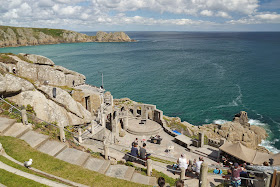
Minack Theatre

Continuing along the coast from Minack, where we were lucky enough to enjoy a little of a rehearsal for a forthcoming performance of Puccini's Tosca, we soon approached the pretty, sandy beach of Porth Chapel, with St Levan's Well above it.

We followed the path along the cliff-top to descend to the tiny hamlet of Porthgwarra. It was only as we were climbing up the other side that we realised that it too had a pretty, sandy beach, with interesting caves at the back. Fun for the kids!


We were now on a sort of high heathland plateau whose plainness was enlivened by two mysterious structures. The OS map identifies them as "landmarks", which does remind you of the original meaning of that word. 


Turning Gwennap Head with its Coast Watch station, we had our first view of the white buildings which identify Lands End. It was clear that two or three miles of rocky terrain lie in prospect.


The first main bay had such massive rock erosion that we briefly wondered whether it was the remains of some wartime engineering work - submarine pens perhaps.There was a disturbing amount of scum floating on the surface.


The next bay, Mill Bay or Nanjival, had more of the same and required a typical Coast Path descent and immediate ascent to negotiate. There was a strong smell of seaweed.


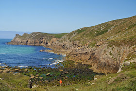
As we started the ascent a glance back revealed a fascinating fissure in the cliff face. 


This was followed by a rather precarious cliff-side section. After Carn Boel the terrain became a bit flatter and out to sea some marvelous rock formations could be seen. The rock arch is called Enys Dodman and the rocky outcrop beyond it is the dramatically named Armed Knight. The Longships with their lighthouse are further out. 


Reaching Lands End was even more of an anti-climax than I had expected. After an animal farm the white buildings seen from afar are revealed as the Lands End hotel (with sea views!) and next to it this horrific structure. 


It looks like a shopping mall I quipped. No, wrong, it is a shopping village. We gave it a wide birth and continued on towards Sennen. Here is the next section of coast, not so very different from what has gone before.


And here is the wonderful Whitesands Beach at Sennen Cove, the end of this expedition to the coast, which does mark a change.


Conditions: warm, initially sunny, but clouding over later.

Grading: Moderate.

Distance: 6.4 miles (distance now covered 374.3 miles.

Map: Explorer 102 (Land's End).

Rating: four stars.

Sunday, 13 July 2014

Lamorna Cove to Porthcurno (South West Coast Path 61)


There's not really much to Lamorna Cove: a few houses, a cafe and shop and a ruined quay - and a surprising amount of car parking. We climbed up past the car parks to embark upon a very rocky path towards the headland of Lamorna Point. Above is the view from Carn Mellyn to Carn-du on the other side of the cove.

We continued along a very rocky path to soon have a great view of the small lighthouse at Tater-du.


We walked behind Boscawen Point and looked back towards the lighthouse. The land on the horizon is the Lizard Peninsular.


The coastline ahead was rock-strewn.


We were also struck by the rock formations of the point itself.  


We descended right down to sea level and the back of the boulder beach of St Loy and were puzzled by this rusty three-legged structure.


As we left the beach a little stream entered it flowing under a stone bridge that carried the Coast Path.


We climbed through woodland and passed behind Merthen Point to reach a high point above Porthguarnon Cove. Here there was a classic Coast Path descent to almost sea level and immediate climb back to the cliff-top.


A further descent soon after this brought us to the tiny fishing village of Penberth and another climb up to the cliff top. Now there was a grassy plateau to cross behind the Teryn Dynas iron age hill fort.

As we approached Porthcurno we could see below us a sandbank just visible above the Mediterranean sea. By walking a few steps down the hillside I could see that a golden beach lay on the shore side.


We stopped for lunch in Porthcurno and walked past its fabulous sandy beach towards the Minack Theatre.


It was reasonably uncrowded, but must presumably be manic in the school holidays. The view back to the rocky headland mysteriously called Horrace was delightful.


We finished today's leg by climbing steeply to reach the Minack Theatre. This was founded by Rowena Cade and had its first performance as long ago as 1932. Minack means rocky place in Cornish.


Conditions: warm and sunny.

Grading: Strenuous.

Distance: 5.7 miles (distance now covered 367.9 miles.

Map: Explorer 102 (Land's End).

Rating: four stars.

Saturday, 12 July 2014

Penzance to Lamorna Cove (South West Coast Path 60)


We turned right out of our B&B and walked along the Western Promenade with the wide expanse of Mount's Bay to our left. After a shortish time we are forced away from the promenade because the sea wall is being repaired, reconstructed even. More damage from the February storms no doubt.

We follow the road into Newlyn and admire the 1894 art gallery, above.  It was designed by James Hicks for the Newlyn School of Art. The brass panels depict birds, mammal, reptiles and fish.

We were now able to rejoin the coast path proper at this dramatic statue of 2007 by Tom Leaper. It is a monument to fisherman lost at sea. The building works can be seen behind the statue while St Mary's church and the Penzance Lido are in the background.


Newlyn was once a fishing village and artists colony, but now it is an unglamorous commercial fishing port, one of the largest in the country. As we climb the road out of it there is an interesting view back across the bay to Penzance. The lighthouse at Newlyn harbour mouth can be seen to the left. It seems appropriate that fishing is a major leisure activity. 


We follow the path past Penlee Point to come down to Mousehole. We are surprised to find a sandy beach at the back of the small harbour, with families enjoying themselves among the hawsers.


In the village we are struck by the 14th century Keigwin House. Apparently Lord Keigwin was killed in a raid by the Spanish in 1595. It is the oldest house in the village, although the porch on its four granite posts dates from about 1700 according to Pevsner.


It is a steep climb out of Mousehole, but there is a great view looking back.


The next section is much more unspoilt, with a very rocky path and some steep climbs and descents. This is a view back across Mounts Bay. St Michael's Mount can be seen on the horizon.


It was good butterfly territory and we saw many Gatekeepers as well as Red Admiral, Small Tortoiseshell, Peacock, Comma, three species of White, Ringlet, Meadow Brown, Speckled Wood and Large Skipper; twelve species in all.

At Carn Du point the not very inspiring Lamorna Cove came into view. The pretty name turns out to be misleading.


Looking back, the rocky headland of Carn Du was quite imposing.


Conditions: warm and sunny.

Grading: Moderate to Mousehole and Strenuous thereafter.

Distance: 5.6 miles (distance now covered 362.2 miles.

Map: Explorer 102 (Land's End).

Rating: four stars.

Friday, 11 July 2014

Praa Sands to Penzance (South West Coast Path 59)


We rejoin the Coast Path at the lovely Praa Sands. (We pronounce the name as Pra, but our taxi driver, Ian, tells us the locals pronounce it Pray.) As we climb up away from the beach there is a nice view back which includes one of last time's surprises, Pengersick Castle. The RNLI lifeguards can also be seen on the beach getting ready for another day's work.

We pass round the back of Hoe Point and the wide sweep of Kenneggy Sand lies before us.


On the left is what seems to be a large private house, unusually positioned right on the shoreline. We walked around the back of the cove, past some holiday cottages and behind the large house to then pass Bessy Cove. A little further on we were delighted to see Fulmars nesting in the cliffs above Piskies Cove.


We were now seeing lots of Gatekeeper butterflies: the first of the year. We also saw five or six examples of the rather splendid Magpie Moth.


Soon we reached Cudden Point which offered a good view back along the rocky coastline. 


The next section followed a cliff top path with the same sort of rocky ledges below and as we approached Perranuthnoe we had our first clear view of St Michael's Mount under increasingly cloudy skies.


We paused for an early lunch at the excellent Victoria pub in Perranuthnoe and continued, now in drizzle, towards Marazion. St Michael's Mount and its causeway became progressively clearer, but the weather showed no sign of improving.


Probably the most interesting view was from Marazion, with the tide coming in and the narrow causeway mostly under water. St Michael's Mount was given to the Benedictines, the same order as had possession of Mont Saint Michel in France by Edward the Confessor in the 11th century. There are still remnants of a 12th abbey and castle. The abbey was sold after the Dissolution of the Monasteries, passing into the hands of the St Aubyn family in 1657. The family still live there, although the property is now owned by the National Trust. 


It remained only to walk the 2.5 miles to Penzance along the footpath at the back of the wide sandy beach. This was not enhanced by the poor state of the footpath or by the increasing gloom and drizzle.


We passed the Jubilee Pool on the way to our B&B. It dates from 1935 and is in restrained art deco style. From the outside the white painted concrete seems excessively functional and rather ugly.


But the internal view has a kind of stern elegance. The pool is currently shut because of storm damage, so of which can be seen in the picture and there is doubt about whether it will reopen. It is Britain's largest remaining lido.


Opposite is the art deco Yacht Inn.


It's not on the coast, but I can't leave this post about Penzance without mentioning the Egyptian House in Chapel St.


This extraordinary building dates from 1835-6 and was built for John Lavin as a showroom for his mineral and fossil dealership. (Why this required an Egyptian theme is less obvious, although Pevsner implies it was something of a fashion at the time.)

Conditions: mild but grey, later on drizzle then rain.

Grading: Moderate.

Distance: 8.9 miles (distance now covered 356.6 miles.

Map: Explorer 102 (Land's End).

Rating: four stars.