Pages

Sunday, 30 December 2012

London: Notting Hill

The Coronet

After a packed Christmas period and extensive rain we saw today as the first opportunity for a while to get out for a walk. But walking in the country would inevitably still be wet and muddy so it came to me that we could go into London and do a city walk instead. We picked this one from the excellent London's hidden walks (vol 1) by Stephen Millar which we used to walk around Southwark in June.

The walk begins at Notting Hill Gate tube station - the "gate" was apparently a toll gate - and continues west past the wonderful Coronet cinema, originally a theatre, dating from 1898. The colour scheme and neoclassical decoration put me in mind of St Petersburg.

Soon you turn right to reach Ladbroke Sq, part of the vast Ladbroke estate of imposing houses built from the 1820s onwards.

On the side of a large house as you enter the square is this striking memorial to "Jan Palach and those who died for a free Czechoslovakia". Nobody my age will easily forget Palach setting himself on fire in 1969.

You soon reach Ladbroke Grove and the striking St John's church of 1845. The area around it had briefly been used as the Hippodrome race course during a pause in the development of this part of west London and the influence of the race course remains in the street pattern and one or two street names.


Heading further west you reach Potter St, where our eye was caught by the brickwork of the courtyard by the St Francis of Assisi church of 1860.


This was at the limit of the Ladbroke estate and the area beyond was used for pig farming and pottery manufacture. Surprisingly, a bottle kiln remains on the edge of a small 1960s housing development.


Now heading back north east, you soon reach the handsome - and very expensive - Elgin Crescent.


This extends almost all the way to Portobello Road, becoming a bit more run-down as it gets closer. We walked up and down Portobello Road to see this lively street for the first time. We were struck by how many foreign tourists there were - presumably it must be on the must-see lists of tourist guides to London. The French at least would be at home with the number of crepe stalls.


We resisted their temptations, but sheltered from a sharp shower in a very nice cafe. Towards the other end of Portobello Road is the Electric Cinema - England first purpose-built cinema, dating from 1911.


Nearby is the original of the Travel Bookshop from the film Notting Hill. I confess I don't see the appeal of spotting film sights, but we had a quick look and had to move out of the way to allow a group of tourists to take pictures of each other in front of it.

Not far away, we came to the Tabernacle in Powis Sq. It dates from the 1880s and was originally an evangelical place of worship. It is now a music venue, bar and restaurant.


Round the corner is the pretty St Luke's Mews, notorious for being where Paula Yates died.


The final section of the walk was a bit under-whelming. We walked up to Tavistock Cresent past Jade Jagger's shop and reached Portobello Road again, moving in to a sort of Spanish quarter, with a celebrated delicatessen and a Spanish School, located behind prison-like walls in a former Franciscan convent.


Our guide explains that the Spanish presence in the area dates from the arrival of refugees from the Spanish Civil War in the late 1930s.

Further up we eschewed the opportunity to photograph Erno Goldfinger's horrific Trellick Tower - the awful tower block you see from the train going into Paddington, with the semi-detached lift shaft. I know it is now a Grade II listed building, but it remains to my mind a symbol of the horrors of Brutalist architecture.

The final point of note was the Carmellite Convent of the Most Holy Trinity, dating from 1878. We ended the walk at Ladbroke Grove.


Distance: four miles.

Conditions: cloudy but bright in parts, a couple of showers.

Rating: three stars. Interesting in parts and reveals a lot about the growth of London in the 19th century. To my mind, too many of the points of note concerned people who chanced to live there, rather than the intrinsic merits of the buildings themselves.

From: London's hidden walks (vol 1) by Stephen Millar (Metro Publications).


Monday, 10 December 2012

Standing Hat near Brockenhurst

Grassy mounds at the start of the walk


We were on our way to stay in Poole for a couple of days and we decided to begin exploring the New Forest on the way. This walk comes from the Pathfinder Guide for Hampshire and the New Forest.

The book proposes a start at the Standing Hat car park, near Brockenhurst, but the road leading to this was closed so we started instead from Balmer Lawn, just off the A337. Initially you are in a wide open landscape with watercourses, ponies and distant trees. We were struck by the number of small grassy mounds. Googling reveals they are the dried-out bases of purple moor grass tussocks.

Soon after reaching the Standing Hat car park - a Hat in the New Forest is a small hillock topped with trees - we entered the forest proper, following a gravel track between trees.


The track winds left and right and then passes a ride on the left named after the celebrated naturalist Frederick Frohawk.


A helpful sign board revealed the existence of the Silver-Washed Fritillary and rarer Pearl-Bordered Fritillary in these woods: I will have to come back in the right part of the summer! Frohawk named his daughter Valezina, which was not an early example of the modern trend towards made up names, but rather the name of a rare variety of the Silver-Washed Fritillary. A man truly devoted to his calling!

Further along the gravel track we came to a T junction where a what seemed to be a family group of ponies were basking in the sun, asleep.


It seems a bit ridiculous to single out a few trees from the thousands which surrounded us, but I did like this clump of Silver Birches which we passed shortly after the ponies.


There seemed to be less to remark on in the remainder of the walk. We entered Denny Wood and began the return part of the loop, past a couple of houses (what were they doing there? I wandered). We continued through Stubby Copse Inclosure (an Inclosure is an area of the Forest reserved for growing timber: commoners' animals are excluded. Everything you might want to know about the Forest can be found on its website.)

The final section back to the car park ran parallel to the railway line through the Forest. We passed the unremarkable Victoria Tilery Cottage - thought to have once been the home of the manager of a brick and tile works whose products were used for drainage works funded by the railway company.

By the time we reached the end clouds had begun to form, giving the sky much more drama. I have learned a lot this year about the value of clouds to landscape photography.


Conditions: clear, sunny, 6 or 7 degrees.

Distance: 5.5 miles.

From: Hampshire and the New Forest (Pathfinder Guides).

Map: Explorer OL 22 (The New Forest).

Rating: three and a half stars. I have to confess that the novelty did wear off a bit towards the end. No doubt it would be better in summer.

Sunday, 9 December 2012

Kirtlington to Islip (Oxfordshire Way 5)

Kirtlington Park

After quite a long break, we resumed our journey across Oxfordshire with Merv and Pud, picking up the route in the village of Kirtlington. The day had started grey but we entered Kirtlington Park under a blue sky. It is a delightful space, laid out, almost inevitably by Capability Brown, in 1755-62. Kirtlington Hall could be glimpsed through the trees.

Soon we entered farmland and now had a clearer view of the Hall, described by Pevsner as "a handsome Palladian house of local stone". We especially liked the separate pavilions with their cupolas.


The house was built for Sir James Dashwood in 1742-6. The architects were William Smith and John Sanderson, who owed much to designs submitted by James Gibbs in 1741.

Now it was across fields to emerge in the village of Weston-on-the-Green, where we soon found St Mary's church. We received a very warm welcome here and had a pleasant chat with the vicar. The church tower is 13th century, but the wide single nave has a Georgian look from outside and was in fact rebuilt in 1743. The windows are Victorian. The inside is fairly plain, but the south doorway is very handsome.


Leaving Weston, we passed the back of Weston Manor, a medieval house remodeled in 1540 and now a hotel.  Soon we crossed the busy A34 road and continued on a concrete road leading to Oddington Grange, accompanied by the sound of extensive shooting off to the left. The Grange seems to have become a location for agricultural light industry.

We couldn't find the expected right fork and had to improvise to find our way back to the official route. We now continued across wet and muddy fields, pretty much all the way to Islip. There was just a hint of moisture in the air, but it was surprising to see a rainbow behind us, extending into the clear blue sky adjoining the clouds.


At Islip I took a quick photo of St Nicholas church. The oldest part dates from about 1200, but what you see today is the result of the usual Victorian restoration. We lunched in some style in the Red Lion.


Conditions: quite cold, but bright.

Distance:  6 miles. Distance now covered 33.5 miles.

Maps: Explorer 180 (Oxford, Witney and Woodstock).

Rating: three stars.

Friday, 7 December 2012

London Bridges Walk

Albert Bridge: The start of the walk

We met our friends Dave and Chris to do this walk from Albert Bridge to Tower Bridge, which they had previously twice done for charity. The Thames Path follows the North Bank and there is a helpful description of that route on Walk London website.

We started by crossing the elegant, recently restored Albert Bridge (1873) - the only bridge on the route that I had never seen before. A helpful sign says that "All soldiers must break step when marching across this bridge". It is directed at soldiers from nearby Chelsea Barracks and reflects the bridge's tendency to vibrate under heavy traffic.

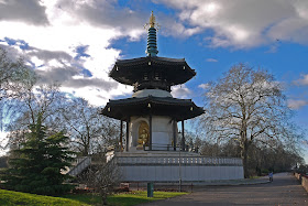
We turned left into Battersea Park and followed the riverside to soon reach the Peace Pagoda.


It was opened in 1985 and the permission to build it was the last legislative act of the Greater London Council. According to Wikipedia, there are Peace Pagodoas in many palces across the world, designed to provide a focus for people of all races and creeds, and to help unite them in their search for world peace. Most were  been built under the guidance of Nichidatsu Fujii, a Japanese Buddhist monk.

Next up is Chelsea Bridge. It dates only from 1937, replacing a Victorian bridge which had become unsound.


We crossed over here and followed the north bank to Vauxhall Bridge, which looked very colourful in the bright sunshine. It dates from 1907 and also replaced an earlier one, which in turn had replaced a ferry.


On the bridge several vehicles had been stopped as part of some sort of police operation. In the background is the distinctive shape of of the MI6 building. Our conversation turned briefly to Bond movies.

Back now on the south bank, we headed towards Lambeth Bridge (1932), with the Houses of Parliament in the background and London Eye to the right. The red colour scheme is said to reflect its proximity to the House of Lords (whose seats are of course red). Westminster Bridge, being nearer to the green seated House of Commons favours a green trim.


As we approached the bridge I pointed out an interesting piece of art deco decoration on the former London Fire Brigade Headquarters of 1937 (by London County Council architects E P Wheeler and G Weald). It is overall a rather utilitarian building - Pevsner dismisses it as "symmetrical and of no consequence" - but is lifted by the wonderful decoration above the main entrance. A close look reveals galleys, mermaids and chariots among the bas relief and mosaic images.


With just a glance a Lambeth Palace, we crossed Lambeth Bridge and turned right in to Victoria Tower Gardens to be immediately confronted by the Buxton Memorial Fountain (the tower is behind on the left). It commemorates the emancipation of slaves in the British Empire in 1834 and was designed by the architect S S Toulon. It was moved to its current location in 1957.


We then passed a succession of wonders to arrive at Westminster Bridge: Rodin's Burghers of Calais, Westminster Abbey, the rest of the Palace of Westminster. This was easily the most crowded bridge, with frantic photography going on in all directions. I looked up river towards the Golden Jubilee foot bridges and the imposing London Eye.


We followed the south bank now under the former County Hall, past the Eye, a through a Christmas market to break for a quick snack at the British Film Institute. We were not tempted by the matinee performance of Lawrence of Arabia (a strange choice - maybe for the Christmas shoppers?) and headed on under Waterloo Bridge - surely the dullest of all the bridges (Pevsner however praises the elegant shallow curves of its arches).

The next stop is Blackfriars Bridge (1869), with the curious sight of the pillars of the now-demolished Blackfriars Railway Bridge standing beside it in perfect alignment. The capitals of the railway bridge have very attractive designs. The replacement railway bridge is beside the pillars and the construction work which can be seen is connected with Crossrail: the station is being extended across the river.


As you reach the north bank again the French gothic structure that greets you is the second home of the City of London School, built in 1884. The school was relocated to Queen Victoria Street, to the east, in 1986. This run of buildings does not look at all English - for a moment you could easily be in Belgium or northern France.


Soon we came in sight of the Millennium Bridge, with the Shard dominating the skyline behind it.


Before long we were on climbing the steps to join the bridge and enjoyed a great view of St Paul's.


Once across the Millennium Bridge, we followed the south bank, and had a dramatic view of the Tower ahead of us, in sunlight but silhouetted against the darkening sky. I zoomed in with alacrity, lest conditions should change.


We then studied the Italianate old Billingsgate Fish Market (1877), rather dwarfed by the Gherkin and other city buildings behind.


It put us in mind of the Fish Market in Venice, near the Rialto. However, a picture reveals that this was a bit fanciful. Just the arches, I suppose.

We continued to entranced by views of the sunlit Tower as we approached the end of the walk at Tower Bridge, which also looked very striking in the evening sun, with the dark clouds behind.


There was just one last building to record: the striking City Hall, by Richard Rogers. I haven't managed to identify the stone egg.


Distance: 6 miles.

Conditions: cold, but sunny.

Rating: four and half stars. Full of interest and producing a great feeling of achievement. Well done to Dave and Chris for introducing us to it. Expect further London walks!

Monday, 3 December 2012

Upton House and Ratley

 View towards Radway and the Edge Hill battlefield

We met up with our friend Sally for this walk which comes from the Great British walks booklet given away by the Guardian earlier this year and is also available on their website, but we cut off a bit to save time. We left Upton House car park and followed the road to join the Centenary Way at Edgehill Farm. (The Centenary Way is 100 miles long and was created to celebrate Warwickshire's 100th anniversary. The Council's website says where it starts and explains that it can be found on OS maps - a bit pathetic as information goes.)

The path follows the edge of an escarpment with fine views over the plain below, initially obscured by trees, but eventually more open. The dominant element in the foreground (see above) is Radway Grange. The house was originally Elizabethan, but was substantially altered by an 18th century owner, Sanderson Miller.

Behind and to the left of the house is the site of the Civil War battle of Edge Hill (1642). It was the first pitched battle of the war but did produce a conclusive result.

Opposite the village of Edgehill, we paused to enjoy further views of the plain and look back along the edge of the scarp towards the distant hills beyond.


We climbed some steps, grandly marked on the map as Jacob's Ladder, and were rather staggered to see a large crenelated tower above us. This turned out to be the Castle Inn and we were sufficiently impressed to stop for lunch. The castle dates from 1746-7 and is, in Pevsner's view, "really very picturesque". It is impossible to disagree. Interestingly, it was the work of the same Sanderson Miller who altered Radway Grange, and was presumably a classic folly on a hill, designed to improve the view from the house.


We carried on along the scarp path and soon turned right, now along the Macmillan Way, into Ratley.  This long distance path was developed to support the Macmillan cancer charity and runs 290 miles from Boston in Lincolnshire to Abbotsbury in Dorset.

We only skirted the village however, so missing its gothic church, and climbed across some very indented country ...


 ....to reach Uplands Farm and follow a track and then roads back to Upton House. It dates from 1695, but was altered in the 19th century and during the early 20th. It came into the hands of Lord Bearsted, the wealthy owner of Shell Petroleum, in 1927 and still houses his superb collection of pictures, including works by Breughel, Durer, Rogier van der Weyden, El Greco, Constable ....

 Our first proper look at the house was from the end of the long drive ...


 ... but we thought the south front was more impressive.


 As you walk down the long lawn away from the house, you can a grassy ridge in the near distance, but all of a sudden the lawn ends and a sunken garden is revealed in a dip between the lawn and the high ground. It is quite theatrical and rather wonderful.


Distance: about 5 miles.

Map: Explorer 206 (Edge Hill and Fenny Compton).

Weather: bright but cold.

Rating: four stars.