Pages

Tuesday, 31 May 2011

Norden, Blue Pool and Corfe

Norden Station

This walk begins in the car park at Norden station near Corfe Castle, where most other people were catching the steam train to Swanage. You leave the car park, cross the road and head north (appropriately) to a locality called, for some reason, Scotland.

The path leads across alternating fields and woodland. On the edge of the first section of wood and in the next large field we saw these curious wooden structures, which seemed rather like a rustic tennis umpire's chair. We still have no idea as to their purpose; on hearing a pheasant, we wondered if they may have something to do with pheasant rearing.


At Scotland Farm, you turn left (i.e. west) and head along a pleasant lane, then a track, with views across open land to Corfe Castle.


You eventually reach the busy A351 and continue, after crossing the disused section of the railway line, across Norden Heath to reach the entrance to the Blue Pool. This is an old clay pit which has - obviously - filled with water which has turned blue. It is surrounded by nicely arranged gardens, paths and places to sit, and a tea room. The Pool itself is very pretty.


The story of ball clay mining in the Purbecks can be discovered at the Purbeck Mineral and Mining Museum near Norden Station - or from its informative website. There is evidence of clay mining in the
area from Roman times, but two fashions gave it a massive impetus: the introduction of tobacco in the 16th century created a demand for clay pipes and the fashion for tea drinking in the 18th century which led to the growth of Staffordshire china making. Josiah Wedgwood regarded Purbeck Blue Clay as the best in the world for making his wares.

On leaving the Blue Pool, we soon joined a path back to Corfe which runs through some delightful woodland parallel with the Purbeck ridge. Further evidence of clay mining could be seen on all sides. This in fact was the return leg of an earlier walk from Corfe along the ridge which we did last November. After a while you climb up through a campsite towards the ridge, with nice views to the west, away from the tents and camper vans.


You then continue along a line parallel to the ridge, but higher up, to skirt Corfe Castle, taking yet another picture.


The final leg of the walk follows the Purbeck Way from the Corfe Visitor Centre alongside the railway back to Norden. I was pleased to be offered an opportunity for an action shot of the train as it came past. I was amused to see that it was pulled by a streamlined Battle of Britain class locomotive (a "flat top") which I recorded in my notebook when I was a boy. 34070 Manston for the record, named after an airfield in Kent.


Conditions: 14 degrees or so, sun, quite windy.

Distance: 6 miles or so, including the tour round the Blue Pool.

From: walkingworld.com [ID 3771].

Map: Explorer OL15 (Purbeck and South Dorset).

Rating: three and half stars. Interesting and varied.


Flower of the day

I can't recollect ever noticing this Dove's-foot Cranesbill before. The tiny flowers are very close to the ground, but provided an intense spot of colour beside the path through one of the areas of heathland.


Wednesday, 25 May 2011

Beech Hill (Mystery Walking)

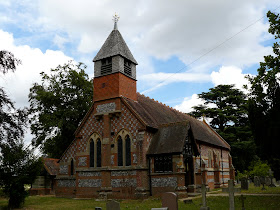
St Mary's Beech Hill

The Ramblers are running a project in which members are asked to walk two miles of path in a given grid square and then rate the walk along a number of dimensions. The walk has to stay within a single Highway Authority area, and clearly once enough ratings are available a national picture will emerge about the state of paths which will highlight differences between local authorities. This all seemed a good idea, so I volunteered and was allocated a grid square quite near home.

The first challenge was to construct the walk. I know that I am not very good at this, tending to rely on walk books rather than make up my own walks, and I have realised that one of the obstacles is that I am poor at assessing distances on the OS Explorer maps. This is pretty pathetic of course and so I thought I would use my experience of Mystery Walking to address this weakness.

The grid square in question only has one real path and it can only be accessed from two points. Secondly, the grid square is right on the extreme edge of West Berkshire District, so only one direction of walk was possible. I decided to park in Beech Hill, opposite the beautiful church of St Mary (William Butterfield, 1867). I walked towards Spencers Wood to join a path through Beech Hill coverts to join my target path right at the top of my grid square.

The path was in fact a Byway and wound through trees to briefly become a road and pass Beech Hill House, an imposing Georgian mansion of 1720.


The path resumed shortly after and continued through woodland on the same south-westerly line.

It ended at a road, like many paths in this area, and I followed two short sections of road to join the Devil's Highway - a one-time Roman Road heading towards Silchester (Roman Calleva Atrebatum). I have waled in the other direction along this section on a walk from Stratfield Mortimer to Beech Hill. It is a very pleasant green lane, with glimpses of fields on both sides.


When the Devil's Highway ended, there was the option of completing the early walk in reverse, but time was running out. The price of not doing so was two and half miles back along the road. Still, I was lucky enough to be get a good look at a kestrel sitting on a telegraph wire - the sound of my approach was presumably drowned out by the traffic noise.

Conditions: warm, but cooling as evening arrived.

Distance: about 7 miles.

Map: Explorer 159 (Reading, Wokingham and Pangbourne).

Rating: two and half stars. Too much road!


Reflections on Mystery Walking

The Mystery Walker rating process was quite straightforward and it was quite interesting to focus on the quality of the paths, rather than the countryside, nature and buildings as I usually do. Ratings were required for (man-made) Obstructions, Signposting & Waymarking, Surface, Overgrowth, Level of "Welcome" and Enjoyment. All of these were rated on a five point scale from Excellent to Terrible, with each point defined in words, which should help to reduce the inevitable element of subjectivity.

I think it is an interesting initiative and it will be interesting to see the results.

My only concern was that the "Satisfactory" point on the scales seemed to be pitched too low. Consider the rating scale for Obstructions (examples of obstructions were "dangerous stiles; paths which have been ploughed or cropped without reinstatement of the route; missing bridges; unopenable gates; strategically-placed muck-heaps"):

Excellent there were no obstructions on the walk
Very good there were a few minor obstructions on the walk
Satisfactory there were some obstructions on the walk but they did not interfere with the walk as a whole
Not very good some parts of the walk were virtually impassable due to the nature of the obstructions faced 
Terrible the walk was almost impossible to carry out due to the obstructions faced

Given the definition of obstructions, I can't see how having some (i.e. more than one of them on a walk could be seen as satisfactory). It is also clear that there are two dimensions at play here: the number of obstructions and their severity.

In general for social survey questions (which is something I am involved in professionally), I am very keen on five point rating scales balanced about a midpoint, but here I rather think a four point scale would work better. Here is my offer:

Excellent there were no obstructions on the walk
Satisfactory there were only minor obstructions on the walk, but they did not interfere with the walk as a whole
Not very good there were frequent or serious obstructions, but it was still possible to complete the walk
Terrible the walk was impossible to carry out due to the obstructions faced

Reflections on map reading

I noted down times and step counts as I did different sections of the walk and compared them with the map when I finished. This helped to fix a greater sense of map distances as translated into walking time distance in the moment.

At home I finally gave the Explorer map scale a careful study. It is 1:25,000 scale so 4 cm represents 1 km, or 2.5 inches (6.5 cm) represents 1 mile.

Or, perhaps more practically, one grid square is 1 km or .62 miles; 2.5 squares is 1.5 miles.

I think I have got it at last. What was difficult about that? Of course the next challenge is to factor in the effect of climbs and descents - what the French call dénivelisation (change of levels).

Sunday, 22 May 2011

Coaley Peak to Wotton-under-Edge (Cotswold Way 10)

View from Coaley Wood

Back on the Cotswold Way with Merv and Pud., after a break of almost two months. We resumed the walk at Coaley Peak and follow the Cotswold escarpment south to Coaley Wood, where I captured the fine view to the west. It would have been more normal to capture the view from Coaley Peak, but unfortunately a sharp shower struck just as we were setting out.

The path then descended through woodland to pass Hodgecombe Farm and emerge in a valley opposite Cam Long Down.


The change of level to the top of Cam Long Down was almost 100m and the section just below the tree line was especially steep. You emerge onto a thin ridge with fine views in all directions.


Looking back to the right (north east) the classic patchwork field pattern was very much in evidence, with a few highlighted in a patch of sunlight.


You now descend into the former wool town of Dursley. The 15th century church of St James is one notable building, but our attention was grabbed by the Market House and Town Hall of 1738. The statue depicts Queen Anne.


A second steep climb leads up to Dursley Golf Club and Stinchcombe Hill. We decided here to take the shorter route across a corner of the gold course, rather than the longer one which goes round the perimeter of the course and then around the side of Stinchcombe Hill.

The route soon became more open and we admired the des res of Stancombe Park, sitting serenely in its parkland.


Soon we reached and walked through the quiet - but wonderfully named  - village of North Nibley. At the edge of the village the route follows a steep staircase of 120 or so steps ...


.. up to Nibley Knoll, where there is a splendid monument to William Tyndale.


Tyndale was the translator of the Bible into English who was martyred (in Flanders) for his trouble in 1536. He was born in North Nibley. The monument was designed by the Gothic Revival architect S S Teulon and dates from 1866. It is 111 feet high.

You walk along the grassy side of the Knoll and then enter woodland to pass Brackenby Ditches - an unglamorous name for another iron age hill fort to eventually emerge on Wotton Hill, with a view over the town and the surrounding plain.


A plaque explains the story of the trees in their brick enclosure: "Trees were planted here in 1815 to commemorate the victory at Waterloo. They had become thin by the end of the Crimean War and were felled for a bonfire. This walled enclosure was erected and the site replanted with trees to commemorate the Jubilee of Her late Majesty Queen Victoria (1887), following the burning on this spot of one of a chain of celebration beacons which then spanned the country."

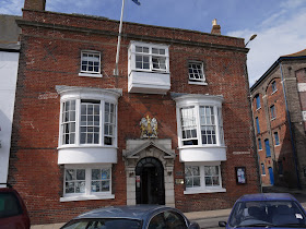
We ended our walk at the Swan Hotel in Market Street, where we enjoyed some much needed drinks and hearty food. Just a short way down the street is the Town Hall of 1872. The columns which partly emerge from the facade are remains of the market built in 1798.

We look forward to seeing more of Wotton next time - it seems an interesting small town.

Conditions: often cloudy, but the threatened rain did not materialise.

Distance: about 9 miles.

Map: Explorer 167 (Thornbury, Dursey and Yate).

Rating: four stars.

Friday, 20 May 2011

Cherbourg

Le bassin du Commerce

Brittany Ferries tempted us with a wonderful offer of cheap day-trip tickets on their Poole to Cherbourg route, so off we went. A sign at the ferry terminal promised a shuttle service to the town centre and also taxis, but as neither was in evidence we decided to follow the example of a large school party and walk into town. This was predictably boring and took about 25 minutes.

The road eventually reaches the Avant Port (the part nearest the sea), with view across the port of boats with a nondescript background of houses and restaurants on the other side.

We walked further along and cross the Pont Tournant (revolving bridge) which separates the two parts of the port. The immediate part of the Bassin du Commerce was more visually appealing (see above) and there was an impressive sailing ship moored on the far quay.


This was the Tenacious, the second ship of the Jubilee Sailing Trust (the other is the Lord Nelson which we saw recently in Dorset). According to the Trust's website "These are the only two tall ships in the world designed and built to enable people of all physical abilities to sail side-by-side as equals."

After a restorative patisserie, in the little square in front of the Theatre, we headed away from the town towards Fort Roule, perched high on Mont Roule.


The fort was originally a 19th century "star" fort, but during the war it was further developed by the Germans into a emplacement for coastal guns, supported by machine guns and mortars facing inland. Cherbourg was base for S-boats (Motor Torpedo Boats) during the war and its defences formed part of the "Atlantic Wall". The D-day beaches are of course not far away and the town itself was badly damaged in fighting after the landings.

This led us to two reflections: in most of France you don't see much remaining evidence of the war, but it makes sense that it should be preserved here.  And as we were having our patisserie, we immediately noticed that there seemed to lots of Americans around - and two American themed restaurants. Ah we thought, like ourselves, people whose parents fought in the war, perhaps coming to see Normandy and its beaches for themselves.

Just a little Googling to find our more about the Fort revealed a website about the Atlantik Wall seemingly listed all existing remains of forts, bunkers, gun emplacements, a blog with wartime photos of the Fort and forums in which enthusiasts shared their interest. I supposed I shouldn't be surprised: previous searches have revealed groups of people with a passion for windmills, water towers and all sorts of other structures.

We did not in fact follow the 1km path up to the top because we knew that the museum housed in the tunnels under the Fort was closed in 2011 and we wanted to save our legs for the rest of the town.

So we headed back into the centre and stumbled on this Art Deco gem.


Magasin Ratti was built 1920-27 in an Art Deco style and designed by Rene Levavasseur. An old photo (taken in 1944) shows that the blank concrete sections were originally windows. However, the corner tower, frieze and decorations above the upper windows remain striking.

We then wandered through the pedestrianised streets of the centre in the direction of the Basilique de la Trinite. There were some interesting old-looking houses and also quite a lot which were in need of, or undergoing, dramatic renovation. This group in rue des Moulins covers all possibilities.


The Basilica, dates from the 14th and 15th centuries. It seems a bit of a hotch-potch and, being on quite a constrained site, is very difficult to get a clear image of. There is a curious sort of high gallery above the nave.


We now adjourned to one of the many restaurants on the Quai de Caligny. In truth we made a poor choice, but the rose de Provence was very good.

After lunch we decided to venture out the north-west side of town to see the ruined Abbaye de Voeu. It was founded in 1145 by Mathilde, daughter of Henry I of England. The visit was all a bit of a disaster: the abbey was much further out than the map had suggested (or I misread the map, if you prefer) and was closed. The ruins were quite impressive, viewed over the wall, and the restored chapel looked appealing.


On the way back we noticed this exposed interior and admired the decorations.


Crossing Place de la Republique, we admired the Hotel Napoleon - located in a late 19th century bourgeois house, according to its website.


Finally, back in the centre, we visited the town's Art gallery, La Musee Thomas Henry. It had an excellent collection of paintings, including a number of portraits by Jean-Francois Millet (better known of course for his paintings of peasants) and a lovely little group of early Renaissance paintings (Fra Angelico, Lippi). Even better, we had the place virtually to ourselves.

Culturally refreshed, all that remained was to walk back to Ferry terminal.

Conditions: sunny, warm.

Distance: A staggering 10 miles in total, according the step count total provided by my pedometer. We were certainly weary enough.

Rating: three stars. We recently did a walk around Weymouth, which is similar in many ways to Cherbourg, but was, we thought, much more appealing. Cherbourg lacks presence: there is no dominant building, square or vista.

Thursday, 19 May 2011

Wareham and Stoborough

Wareham Quay, by South Bridge

This walk starts by Wareham's South Bridge, from where we started our previous walk around Wareham and the river Stour. You cross the bridge, and on the way enjoy a nice view down river, with the Old Granary on the left and the line of moored boats ahead. It was interesting to see how the Black Headed Gulls dominated the middle of the river, while the ducks were all grouped by the banks.


You initially follow the south bank, with lovely views to the south over the water meadows. There are a series of drainage channels which put us in mind of the "rhines" of the Somerset Levels e.g around Allerton Moor.


After passing a sailing club, the route turns right along a lane, following the Purbeck Way, which soon passes through this lovely field of buttercups on the way towards Stoborough Green. The Purbeck Ridge is on the horizon.


You then cross the two roads leading south from Wareham, the B3075 and the A351 to reach Stoborough Heath. You  cross the heath, following a twisting, but very well sign-posted path, to eventually reach the Wareham to Corfe railway line. A sign insists that this is an operational line and threatens extensive fines for leaving the path gates open, but the fact the the rails are shinier on the crossing than either side strongly suggests that it is only operational in some notional world. There are said to be plans to extend the existing steam railway which runs from Swanage to Corfe on to Wareham and this would surely be an excellent thing.

Instead of crossing the railway however we turned right along a path through woodland which was graced with an excellent showing of purple rhododendrons.


There is then a walk of half a mile or so along a road (the walk description called this "some little distance" - it is anybody's guess how long that might be) to reach Stoborough. A right turn onto the road to the RSPB nature reserve at Arne takes you back into the country.

We met a woman and her daughter here who told us that the field opposite their house was often visited by a small herd of deer in the early evening and after jesting that we would look out for them, we were amused to see them (or another herd of course) in the next field. We did not see the white deer that she mentioned.


Conditions: very warm.

Distance: about 6 miles.

From: Walkingworld [ID 4935].

Map: Explorer OL15 (Purbeck and South Dorset).

Rating: Three stars. Some nice bits, but too much road.


Sightings

We saw a Small Copper and a Common Blue in the buttercup field. The latter kindly let me take a nice photo.


And on Stoborough Heath, just as we were lamenting a general lack of flowers, we came on this Early Purple Orchid.

Wednesday, 11 May 2011

Weymouth

Radipole Lake

My birthday. I have a tradition of trying to do something a little out of the ordinary on the actual day and today I developed a plan to visit Weymouth - by train from Poole - go round the RSPB reserve at Radipole Lake, have lunch at the celebrated Crab House Cafe at nearby Wyke Regis, and to complete the day with a town walk to explore Weymouth.


Radipole Lake

Radipole Lake is a nature reserve almost in the centre of Weymouth and only 5 minutes walk from the railway station. Arriving at the excellent visitor centre you are presented with an area of open water surrounded by reed beds. The main lake is fed by the River Wey, from which Weymouth of course takes its name.

We struck out for the North Hide along a gravel path winding between bushes and crossing small waterways.


About a kilometer later, having been serenaded for much of the way by the beautiful sounds of assorted but generally invisible warblers, we reached the hide. We did manage to see a Reed Warbler on the way. During our short stay in the hide, we did not catch sight of the Hen Harrier or Kingfishers we had been told about at the visitor centre, but we did see some acrobatic Common Terns and various ducks and geese.

On the way back we followed the Buddleia Loop into a different part of the reserve. There were yellow Flag Irises in profusion at the edges of the narrow waterways.


Sightings at Radipole Lake

Just before we reached the North Hide, we were stopped in our tracks by some intense warbling which seemed to be coming from a nearby bush. After a while we spotted this Sedge Warbler sitting on a branch and letting rip. I was able to get close enough to take a reasonable picture. This was a delight because warblers generally are notorious for being heard but not seen.


The flower of the day was this gorgeous iris (presumably) - probably a garden escapee, but what a wonderful shade!


The Crab House Cafe

The next stage of the day's entertainment involved a cheat - we walked back to the station and took a cab down to Wyke Regis for lunch at the Crab House Cafe. It is located just off the main road to Portland, just behind Chesil Beech in a wooden structure which could generously be described as unprepossessing.


However, the food is absolutely superb. The turbot steak in saffron cream with mussels was one of the very best dishes I have ever eaten - even the side order of chips was outstanding.

In due course we took another cab back to the Pavilion Theatre at the end of the beach to begin our  exploration of the town.


Weymouth town 

We loosely followed a route available from the Visit Weymouth website. We started by walking out to the end of the Pleasure Pier. It was not at all visually pleasing, but once we reached the end, the view across the bay towards Redcliff Point  was delightful. The end of the south pier can be seen on the right.


We now retraced our steps to reach the end of the Esplanade and the long, curving sandy beach. The curve of the houses and hotels behind the beach was pleasing, especially as they were all of a similar height and apparent age. Pevsner asks "has any town a more spectacular seafront than Weymouth?"


We turned left however to follow the line of the harbour and walk along Custom House Quay, to soon pass the former Custom House itself. It is said that somewhere near here a trading vessel berthed in 1348 and brought the Black Death to England.


As we approached the Town Bridge we were surprised to discover that it is raised every couple of hours to allow boats in and out of the marina. Obvious really. It was built in 1930, the latest in a series of bridges at this point. There is even a webcam, if you want to follow events there.


We crossed the bridge and turned left along the quay (Trinity Road). There was a pretty collection of bow-windowed Georgian houses, which put us in mind of recent visit to Burano. Were they too to help sailors find their way home?


We turned into Trinity Street to see the Tudor House.


The plaque said that it dated from "about 1600", which means that it possibly wasn't a Tudor house at all (Elizabeth I died of course in 1603), or was only very briefly.

We returned to the quay and headed towards the Nothe Fort (seen below from the other bank), completed in 1872 and now a museum.


We climbed the hill behind the fort to reach the delightful Nothe Gardens, with lovely views towards Portland, with its harbour in the foreground.


At the end of the Nothe Gardens we reached Newton’s Cove, where there are further views of the  groynes and breakwaters of Portland Harbour, the second largest man-made harbour in the world. They appear almost continuous, but in fact there are three ship channels. (So what is the largest such harbour? you ask. Jebel Ali in Dubai apparently.) Construction of the harbour began at about the same time as the work on Nothe Fort.

We now headed back towards Weymouth Harbour, passing the former Devenish's brewery, now known as Brewer's Quay. It has not been redeveloped as dwellings in the same way as the one in Dorchester, but perhaps it is only a matter of time.

We crossed the Town Bridge again and walked through the pedestrian shopping streets to reach the Esplanade and the statue of King George III. It was erected in 1809 to commemorate his 50th year as monarch (he came to the throne in 1760). The statue has only been painted since 1949.


According to Pevsner, George paid his first visit in 1789 and came regularly until 1805. Royal patronage helped the town to grow.

In introducing his "perambulation" around Weymouth, Pevsner says "One must of course begin at the statue of George III ..." Perhaps we should have.

Conditions: sunny, warm.

Distance: 5 or 6 miles in all.

Map: Explorer OL15 (Purbeck and South Dorset).

Rating: four stars.