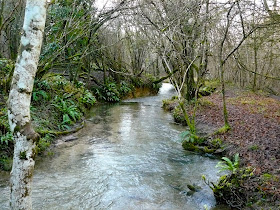
For our last walk of a busy year of walking we decided to revisit one we last did in 2004. The walk begins at the King Charles's Head just outside the village of Goring Heath. We immediately noticed a change: the pub has now been converted, very successfully by the look of it, into a private house. Perhaps not private enough though as the house is right on the road.
A few yards up the road towards Goring Heath you turn into Gutteridges Wood, a very pleasant woodland - and the first photo opportunity for my new camera.
You skirt the hamlet of Nuney Green and go through further woodland to emerge at the surprising and wonderful Allnutts Hospital, almshouses founded in 1724 by Henry Allnutt.
The central building, under its cupola, is the small, plain chapel.
You then pass the edge of Goring Heath and follow a series of paths to reach Path Hill, on one side of a pretty valley. After two more stretches of woodland (Bottom Wood and Coxsetters Wood) you regain the starting point.
From: Rambling for Pleasure around Reading (second series) by David Bounds for the East Berkshire Ramblers Association.
Map: Explorer 159 (Reading, Wokingham and Pangbourne).
Conditions: blue sky, some cloud, very cold, ground frozen.
Distance: 4 miles.
Rating: Three and half stars stars. Very nice woodland; the almshouses are a delight.
Pages
▼
Monday, 28 December 2009
Thursday, 17 December 2009
Sapperton and Daneway
En route for Gloucester, I diverted to the west of Cirencester to do this delightful walk which starts in the pretty village of Sapperton. The start point is the church, originally Norman but now mainly dating from the early 18th century.
From here the route follows the Macmillan Way through farmland and then descends quite sharply to reach the bottom of the Frome valley. You cross the river at a point where a small stream joins and then climb quite steeply again up a sunken track on the other side. This emerges on a high plateau where you walk along the edge of a large field, a short length of tarmac and then another large filed before descending again to the valley at Daneway.
You now walk along the valley bottom along a broad grassy path towards the Siccaridge Woods Nature Reserve, home of the dormouse according to its welcome sign. This is a narrow band of ancient woodland on the side of the valley and along the ridge at the top. Even at this time of year it is a delight to walk through.
You descend again to the valley bottom and cross a bridge over the Thames and Severn Canal. This was opened in 1789 and finally abandoned in 1927 (but see below for recent developments). It must have been a major undertaking as the valley has quite a pronounced slope and so there are a lot of locks in a short distance.
The canal is quite desolate: silted up, overgrown and with ruined locks every few hundred yards. The River Frome runs close by and, by contrast, is clear, clean and fast-flowing.
You pass through the hamlet of Daneway, consisting of not much more than a pub, and soon come on another sad relic of the canal: the entrance to the Sapperton Tunnel, which is no less than 2.17 miles long.
You climb over the impressive entrance portal and up a steep meadow to return to Sapperton.
Distance: 4.5 miles.
From: Cotswold Walks (Pathfinder Guides).
Map: Explorer 179 (Gloucester, Cheltenham and Stroud).
Rating: four stars. Very varied and interesting and a good work out for a shortish walk.
The Thames and Severn Canal
Thanks to Google, I found the website of the Cotswolds Canals Trust, who - thankfully - are engaged in restoring the Thames and Severn Canal and its sister the Stroudwater Canal. The tunnel portal is one example of the restoration work. The site describes the Severn and Trent Way which runs 36 miles from Framilode to Lechlade.
It also turns out that the Sapperton Tunnel was the longest ever built when it was completed and was subsequently exceeded by only two others. Which two? A few more clicks revealed that the Standedge Tunnel on the Huddersfield Narrow Canal is the clear winner at 3.24 miles, followed by the Strood Tunnel on the Thames and Medway Canal (2.23 miles).
Thursday, 10 December 2009
Aldworth
About the walk
After the heavy recent rain, the only place to go for a walk seemed to be the Berkshire Downs. I decided to go to Aldworth and graft some new elements onto a walk I had done before. Although the afternoon was dry and mild, the light was too poor for it to be worth taking any photos.
I started at Aldworth church and followed the nearby track on its curving route towards the Ridgeway. After a while it joins the other main route up, which comes from centre of the village by the Bell pub. I turned left and continued the slowly rising route to reach Starvall Farm, a few hundred yards short of the Ridgeway. (I have always thought that this is a worrying name for a farm - I would love to know where it came from. For once Google yields nothing.)
Here I broke new ground and turned left (i.e west) towards Compton and headed along a slightly muddy track. This soon reached a local landmark - a junction of paths marked on the map as Crowfoot. Obviously, one path splits into three. Here I turned right to follow a sunken lane back up to the Ridgeway.
After a stretch along the Ridgeway I took the track back past Warren Farm to rejoin the route up. The initial section of this track has fine views across the Goring Gap. In fact, I think these are some of the finest in Berkshire. I took a nice photo when I last walked this way, in August.
Distance: 5 miles.
Map: Explorer 170 (Abingdon, Wantage & Vale of White Horse).
Rating: four stars.
Reflections
I was very conscious as I walked of the the steady drone of the traffic noise from the M4 - which is several miles to the South. I can't recall noticing it in the summer and no doubt the absence of leaves on the trees and bushes , and perhaps the prevailing wind, can be identified as explanatory factors. But it is disturbing that there seems no escape from noise, in this, one of the most rural parts of Berkshire.
The other thought I had was how easy it was to pick out a new route from the map in this sort of terrain. There are clearly other excellent walks to be constructed on future days over towards Compton and East Ilsley.
Sunday, 6 December 2009
Bath
We met up with friends for a city walk around Bath, following the City Trail described in the excellent leaflet available from the tourist office.
The walk starts there and our first thought was to look inside the nearby Abbey church, but unfortunately for us a service was underway - fair enough on a Sunday morning.
Then we made an immediate detour into the Roman Baths Museum. This was really excellent, but threatened to derail the whole undertaking so we had to limit our time there. The picture shows the original bath, although the columns, viewing platform and statues of Roman emperors were all added in Victorian times. The join between old and new is fairly obvious.
We were very struck by the original hot spring, where you can still see the steam rising and water apparently bubbling up (the helpful audio guide revealed that in fact this is bubbles of gas).
The museum was very well done and gave a very clear sense of what the original bath and temple complex must have been like. The big insight was that in Roman times the temple was much the more important.
The route then heads west and passes the new Thermae Bath Spa, the only natural thermal spa in Britain, where you can take the waters in hygienic conditions and also swim in the roof swimming pool. You then head up Westgate and pass the Theatre Royal. The current entrance is unprepossessing, but by turning left into Beauford Square you can see the beautiful original facade.
The opposite side of the street has a fine row of what were originally artisans' houses. The route continues up the hill and across John Wood the elder's fine Queen Square, with the "palace" - seven private houses built as if they were a single entity with a central pediment. We saw many similar ones in St Petersburg earlier in the year.
The route then turns into Gay Street, past the celebrated sedan chair houses (they are actually stands where the chairmen would rest their chairs - "houses" caused us some confusion). Then it turns right up steps to the Gravel Walk, off which is the small Georgian Garden. We found this a bit disappointing - we have a better box hedge in ours! One very interesting feature of the rear of the houses which back onto the Walk was how irregular they are: apparently the architects designed uniform fronts, but left the builders to complete the backs according to each customer's wishes.
At the end of the Gravel Walk you suddenly emerge into the vast lawn in front of John Wood the younger's Royal Terrace. A wonderful vista.
A short walk along Brock St brings you to The Circus, designed by John Wood the elder, but completed by his son. This was Britain's first circular street. The continuous frieze at first floor level depicts 513 different motifs, thought to be masonic or mystical symbols.
By now it was time for lunch, cunningly planned to be on the route at the Moon and Sixpence, in Milsom Place, just off Milsom Street. Somewhat later, suitably restored we continued on our way in the gathering gloom. The route turns into the unusually named Quiet St and then into Queen St, off which stands a beautiful house with two curved pediments. It was the home of General Wolfe - he of Quebec fame.
A few more turns bring you to the Corridor, which dates from 1825 - a very early example in England of the newly fashionable shopping arcade (the first, Burlington Arcade , dates from only 1820). The leaflet drew our attention to the balcony where musicians would have played. So music in shopping precincts is not the awful American idea I had supposed!
Then across the road and into the market next to the Guildhall, where you can see the "nail" which gave rise to the phrase, pay on the nail.
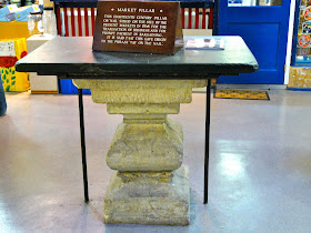
We are now at the river and a quick detour to the right enables you to look back and down to see the Eastgate, the only remaining medieval gateway to the city.
Next up is the lovely Pulteney Bridge, designed by Robert Adam and completed in 1773. When you are on it looks just like a normal shopping street - because it is flat of course.
Along to Laura Place where you can see a hexagonal Victorian postbox.
At this point, we resisted the temptation to go on down the wide Great Pulteney Street and instead returned over the bridge and made our way to the Abbey. The site previously housed a Saxon monastery church and a Norman cathedral, and the present abbey church was founded in 1499. Only 40 years later it was suppressed as part of Henry VIII's dissolution of the monasteries and largely destroyed. Happily is was re-roofed and repaired in 1611. There was also a Victorian restoration and bomb damage during the second world war. Further restoration and cleaning took place in the 1990s. What you see today is a remarkably harmonious and unified building with a high nave with large windows and magnificent fan vaulting in both the nave and the aisles.
Distance: about 2.5 miles.
Rating: four and a half stars. The walk provides a very thorough encounter with the city and there are so many fantastic sights. But am I rating the walk or the city? How can they be separated?
Wednesday, 2 December 2009
Wootton
We decided to venture further afield than usual for our mid-week walk - to Wootton, south west of Oxford. Fairly dismal weather limited the photographic record. The walk begins at the church and initially follows a lane towards Old Boars Hill. After a while you leave the lane and cross fields and then walk through a straggling area of houses to rejoin it higher up. A bit pointless really.
You then enter the Jarn Mound and Wild Garden, owned by the Oxford Preservation Trust. The artificial mound was constructed in the 1930s for Sir Arthur Evans, a famous archaeologist, and apparently commanded fine views of Oxford in its day.
Now, alas, the view is almost completely obscured by trees.
Leaving the Wild Garden - more realistically, a pleasant enough public garden - you pass an entrance to the Open University HQ at Boars Hill, once Ripon Hall, and enter an area of meadows with lovely views towards Oxford.
You can just make out Christ Church in the centre of the vista.
A series of fields and a path across common land led to a track which later became a road leading back down into the village. There were again some nice views from the common. After the common, the track had the odd juxtaposition of a Carmellite priory on one side and an activity centre for scouts on the other - both were well set back however.
The route diverted via another plot owned by the Oxford Preservation Trust, the Elizabeth Daryush Memorial Gardens. This too promised fine views - over the Berkshire Downs - but again trees interposed themselves.
Distance: 5 miles.
From: Chilterns and Thames Valley (Pathfinder Guides).
Map: Explorer 180 (Oxford).
Rating: two and a half stars. Oversold. Some nice views in the middle, but overall too much on roads and too suburban in feeling. The expected views were largely absent.